| Display Unit | HM-5818 |
| Operation System | Linux |
| Software Language | English, Chinese |
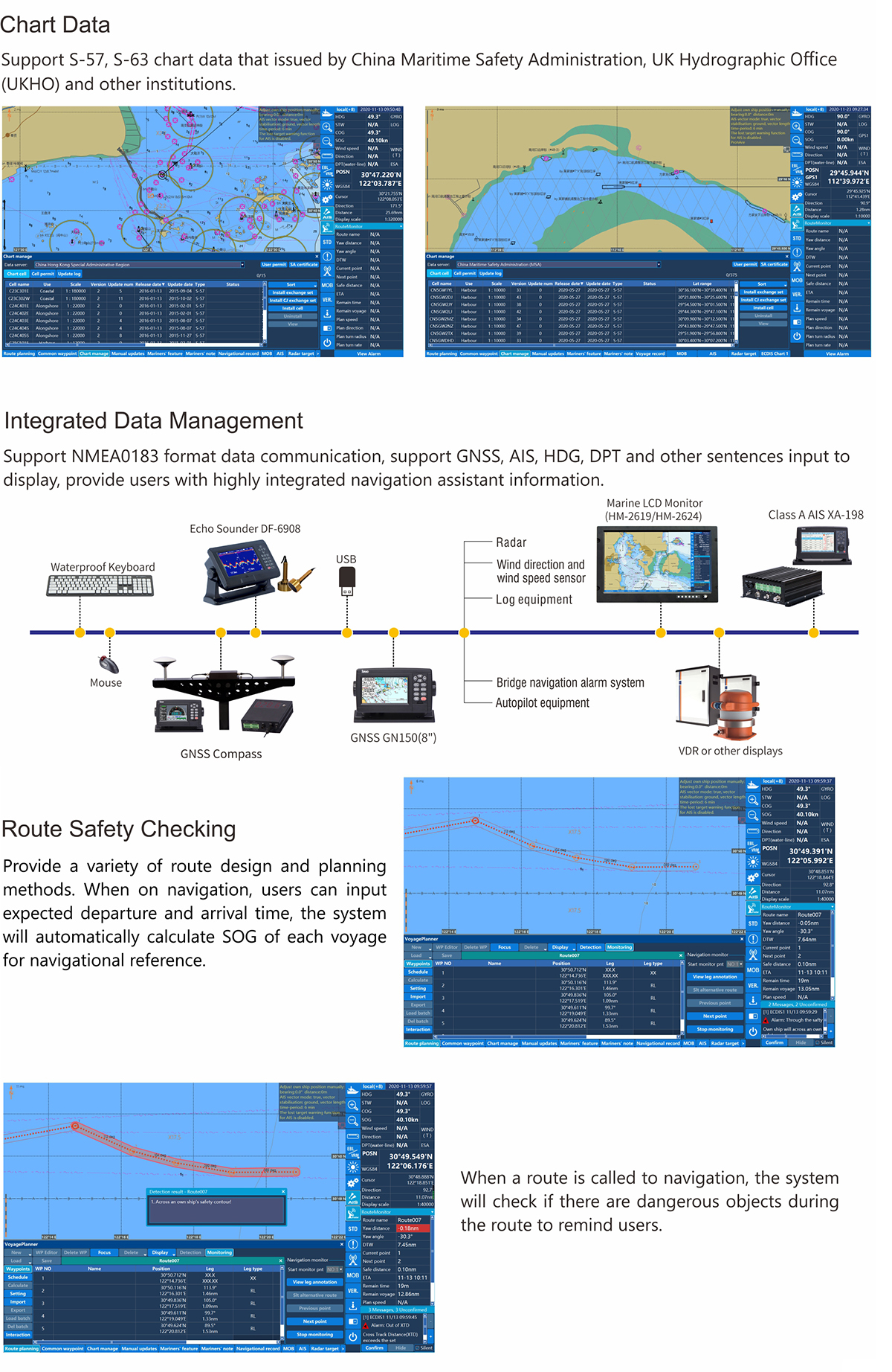
Electronic Nautical Char | IHO S-57 Ed 3.1 Vector Chart (Support IHO S-63 Data Protection Scheme). It support the official S-57 / S-63 electronic chart which is distributed by the UK hydrographic office (UKHO) , the China’s maritime bureau and so on. And it also support the Yangtze river hydrographic electronic navigation chart database. |
| Chart Installation | Install Base/Update S-57/S-63 ENC packages from USB. |
| Manual Update | Add/Modify/Delete objects on the SENCs. Manual updates can be distinguished from automatic updates on the screen on demand. |
| Object Information | Select objects on the charts with cursor, and query informations associated(Texts, pictures, and symbol explanations) |
| ECIDS Chart 1 | The system provides a demonstration chart for new users to learn and familiarize themselves with the S-57 electronic chart and corresponding symbols. |
| Planed Route | Rhumb line/Greate circle line, generates wheel-over-line according to configuration. |
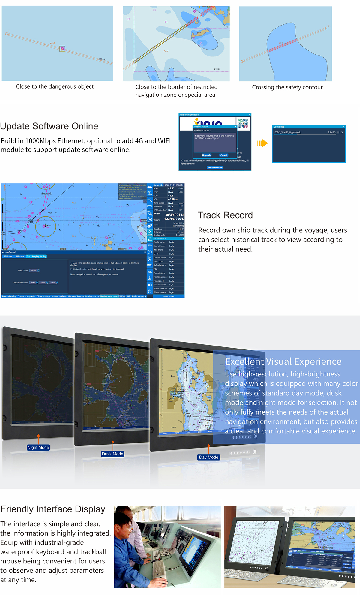
| Route Detection | Detects the following objects which specific planned route crosses, Navigational hazards. Areas for which special conditions exist. Safety contours. Any object of above deteted will be highlighted to mariners. |
| Route Monitoring | Route monitoring detects the following conditions for own ship, Cross track error. Navigational hazards. Areas for which special conditions exist. Safety contours. Indication or warning will be given to mariners if any condition of above happens. |
| Color Palette | Day/Dusk/Night |
| Display Mode | 3 display categories are predefined-Base/Standard/Other. Each category can be customized by mariners to show or suppress some informations of chart. |
Text Display Setting | Provides switch options like import text, light description, Seabed nature, place name etc. Allows mariner to show or suppress some texts of chart. |
| User’s Note | Information (i) or warning(!) label could be marked at specific position. |
| User’s Object | Mariners’concerned point/line/area could be drawn on the chart. |
| MOB | When emergency(like MOB) happening, MOB button on the screen can be clicked to record the position of own ship. |
Own Ship Positioning | Support primary/secondary position source. Last valid position or LOP can be used as start position for dead rocking |
| Voyage Record | Voyage records for last 3 months (position, time, course, speed). Records for last 12 hours are detailed, includes informations of referenced ENCS. |
| Alarm | Alarm or warning for route monitoring, sensor failure, ENC, CPA etc. will be given according to configured priority. Mariners can view and confirm alarms which they received. |
| Measure Tool | EBL/EBRL/VRM |
| AIS Target | ● AIS target query and monitoring.
● Condition setting(CLASS A/B, range, CPA) for activated or sleeping AIS targets to filter unconcerned ones. ● Past track for AIS target. ● CPA/TCPA alarm. |
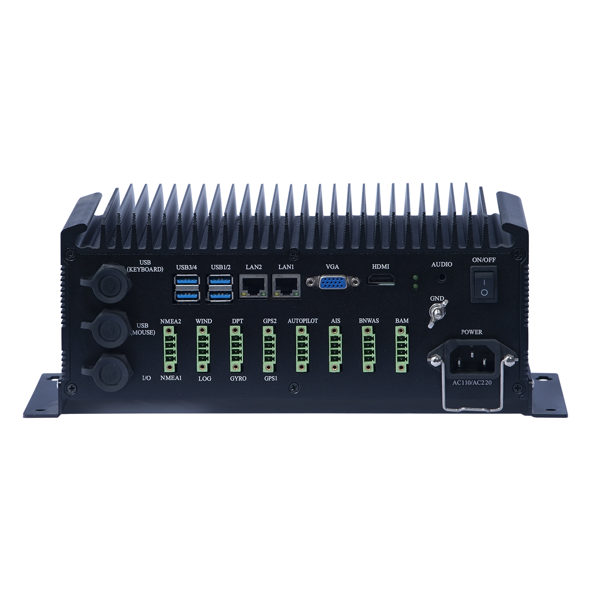
| Sensor | Support NMEA0813 input device like GPS, AIS, echo sounder, gyro, log and so on. |
| Operation Unit |
|
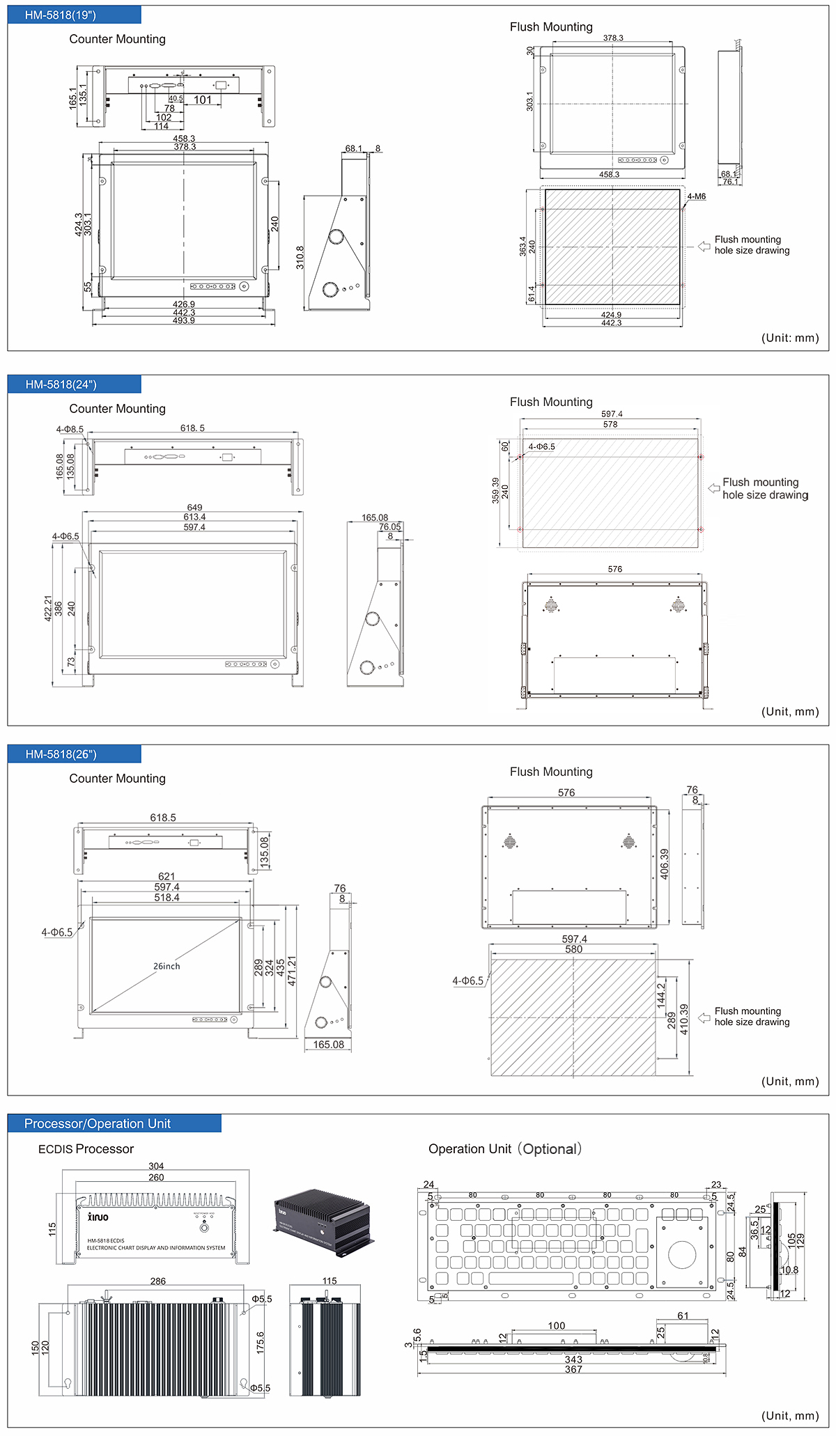
Operation Unit (Optional) | Size, 343mm x 105mm, IP65 Static waterproof dustproof explosion-proof, Stainless steel metal industrial keyboard, built-in industrial-grade IMG PCB, embedded instalation. |
| Display Unit |
|
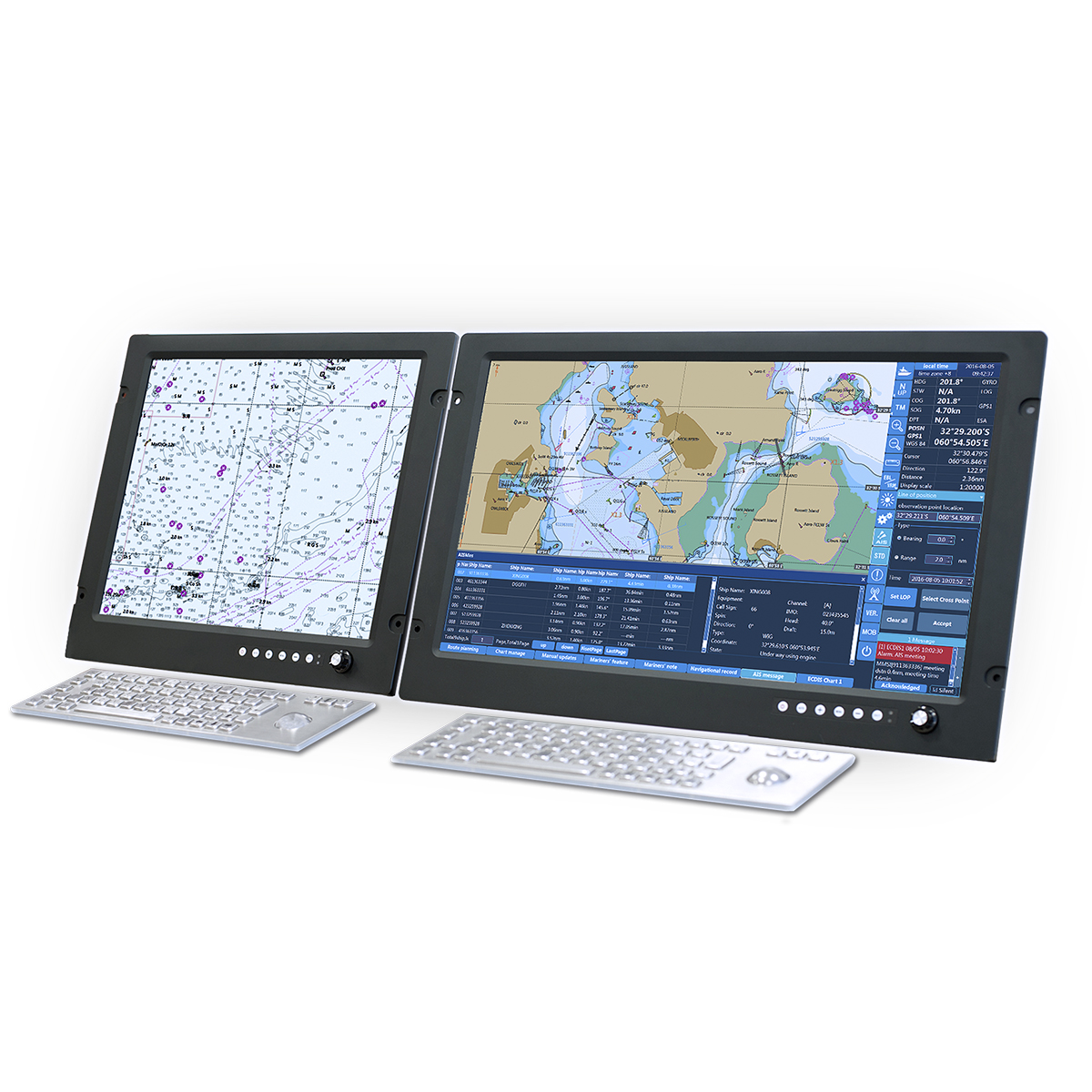
| Model | HM-5818(19") |
| Display Resolution | 1280 x 1024(SXGA) |
| Aspect Ratio | 4:3 |
| Screen Brightness | 450cd/m2 |
| Screen Size | 376mm×301mm |
| Viewing Angle | Horizontal, 170° Vertical, 160° |
| Contrast Ratio | 1000:1 |
| Model | HM-5818(24") |
| Display Resolution | 1920 ×1200(WUXGA) |
| Aspect Ratio | 16:10 |
| Screen Brightness | 600cd/m2 |
| Screen Size | 518.4mm×324mm |
| Viewing Angle | Horizontal, 178° Vertical, 178° |
| Contrast Ratio | 1000:1 |
| Model | HM-5818(26") |
| Display Resolution | 1920 ×1080(FHD) |
| Aspect Ratio | 16:9 |
| Screen Brightness | 500cd/m2 |
| Screen Size | 597.6mm×336.15mm |
| Viewing Angle | Horizontal, 178° Vertical, 178° |
| Contrast Ratio | 3000:1 |
| Processor |
|
| CPU | Intel Haswell/Brodwell U series 15W |
| Memory | DDR3-1066 MT/S 4GB |
| SSD | SSD 480G |
| Audio | Audio ALC 662 HD Around a track+the microphone |
| I/O | 6 PIN |
| Ethernet | 1000Mbps |
| Power | AC 220V & AC 110V |
| Power Consumption | 17W or less (220 VDC) |
| Compass Input Port | Support |
| Log Device Input Port | Support |
| GNSS Port | Support 2 ports |
ARPA Input Port from Radar | Support |
| AIS Input Port | Support |
| Video Output Port | VGA , HDMI |
| USB | 4 ports, USB 2.0 type A |
| LAN Port | LAN1, LAN2 |
| Wi-Fi | 802.11b/g/n |
| 4G Module | LTE/GSM, Internal antenna, and support to connect external antenn |
| Environmental |
|
| Operation Temperature | -15℃~+55℃ |
| Storage Temperature | -20℃~+70℃ |
| Language Switch | English, Chinese |
| Manual | English, Chinese |
| User Opteration | Menu operation/double click/zoom by roller |
| Workstation | Split device |
Standard
| IEC 60945, IEC61174(ECDIS), IEC 60529(IP20), IEC 61162-1, IEC 61162-2, IEC 62288,2014, IMO A.694(17), IMO MSC.232(82), IHO S-52, IHO S-57, IHO S-63, IHO S-64, CCS GD 22 Guide for the acceptance test of electrical and electronic products. CCS GD 06 Guide for inspection of electronic chart display and information system (ECDIS). International Maritime Organization navigation safety sub committee NO.266 circular. <electronic chart display and information system software maintenance> |
